Wednesday, 3 December 2014

Day 4 Miena to Ouse

    "Down hill" day today as we drop off the edge of the central highlands and make our way to Ouse.
Today started with our customary 8:00am start (nearly missed it trying to get day 3 blog done) and we left the Great Lake Hotel refreshed for a "rest day" ride to Ouse. We set off down the gravel Marlborough Highway which was fairly flat until the edge of the central plateau then the road descended and we set a cracking pace I reached 60kph on gravel at one stage. The air was cool so I wore my roadie sleeves I bought just before the ride which worked a treat except they were a little big in the bicep area so obviously it was a manufacturing fault and not that I need to work out my upper body a bit more. We followed the highway down into Bronte Park which seemed like only 10 minutes we got there that quick. We grabbed a bite to eat and a drink before setting off down the highway again.
Heading out down the Marlborough Highway

The view over the side of the valley

Entering Bronte

Refuel
 
The Marlborough Highway then meets the Lyell Highway and we were on sealed road again but only for a short while as we slipped off down Victoria Valley Road and back onto gravel. This road threads it's way between several lakes and through a little cluster of shacks called Dee. With a undulating course we had good pace and the road eventually breaks out into farmland and then back into light bush again before we leave the main road and head down a small gravel road sign posted Victoria Falls and past a washed out bridge and across the creek ford next to it and after we climbed back up the other side of the bank we were rewarded with and awesome flowing dirt fire trail that for once I could hold my own out in front. This trail continued and descended into a little more rocky trail before coming to a boom gate around a blind corner at about 10km from the main road. Dale had made us aware of this so it would be wise to check your speed when getting that far in as the gate is pretty solid and there is no going over or around it at speed. Back to reality and we were on the slightly more mundane Lines Tier gravel road, still the was a lot of descent to be had and the pace was hot at times and we made good time to and met up with Victoria Valley Road again. This then took us finally down to Ouse where we stopped and had a feed at the Ouse Road House and then moved on down the street to the Lachlan Hotel where most of us would be spending the night. We had a few drinks in the bar and then an excellent dinner in the restaurant before calling it a night. Didn't seem like a big day but we still managed over 83km (we did average over 22kph) and even though it was a down hill day we still climbed 944 meters but we descended a whopping 1915 meters Tomorrow the plan is to head to New Norfolk but the weather is not looking promising but we will see.
 
Turn off down Victoria Valley Road

Dee

The start of a very fun trail

Nice to be on dirt again

Long descent into Ouse

Surplus Landrovers

Rolling into town

More food

The night accommodation the Lachlan Hotel 


Tuesday, 2 December 2014

Day 2 Sheffield to Liffey

Boy what a day!


The day started on an overcast day with rain threatening, we had some rain overnight and it was forecast for more today. We set off from Sheffield at 8:00am and but after the first decent hill it was jackets off. The trail heads down Formby Road off the main street of Sheffield before heading right onto Old Paradise Road which then joins with Paradise Road through the rolling hills behind Sheffield and farming lands.
Mount Roland in the background


Poppies in flower with Mount Roland in the background

We turned off the main road and followed fire trails along the base of the Gog Range. With the rain from overnight the gravel was great to ride on as it was grippy and no dust. Eventually the trail got closer to the range and then descended down to the Mersey River. Dale was unable to check the river height last night (as he got a little lost) so we were taking a punt that the level was not too high. As it was the river was only about thigh deep at most but the current was fairly strong an you had to make sure you had a good footing before taking your next step. There was a steep climb out of the river bank an back along the edge of the range the trail went as the elevation increased before the re-routed trail pointed us up hill, straight up the range. That hill just kept going and going with only Michael aka the "Mountain Goat" able to ride the whole thing, I rode a fair bit but I must admit there was a couple of places that pushing was required. After we reached the top the trail undulated following the ridge line before plunging down a hill with a bent up old gate right at the base so not over speeding the hill was wise if you didn’t want to end up attached to the gate and its dozen or so padlocks.


Mersey River crossing
View from the Gog Range
Catching our breath after a big climb onto the Gog ridge line

Back on the tarmac and along Mole Creek main road we headed towards Red Hills for lunch. We met the support vehicles at the intersection of Montana Road and Leonards Road and Cheryl had come up with the goods and provided us all with salad rolls and fruit buns to get some energy back into our legs and Barry had the trailer in tow. And that is where the rain started, as we headed along the gravel Leonards Road the rain poured down and any chance of staying dry was long gone. We joined Long Ridge Road and briefly Meander Road before turning down Highland Lakes Road where as the rain eased  off we reached the Tasmanian Trail silver arrow track. This track avoids some of the main sealed road an gets into some of the real mountain bike trails I was looking forward to. With some technical climbs a wicked descent with water diverting flats sections that I was able to get some decent air over it was great fun if a little water logged from the rain. This is where out plans went a little awry as we headed up a slippery hill that was certainly not rideable but Michael gave it a good crack anyway, we arrived at the junction of another fire trail but no little Tassie Trail arrows in sight. Since no one wanted to head back down that hill we kept on going as we weren't that far away from the main road. A few more stops to try to work out where on earth we were, we decided to head up a hill near a half washed out bridge. This fire trail came out near a farmers paddock with tracks heading in two different directions, with a quick look down one track to find another big hill the decision to was made to head across the farmers paddock as we could see the main road so civilization was in sight. After going through the farmers back yard we met the tarmac again, the oddly (aptly??) named Bogan Road. After we looking at our GPS we should have turned left at the bottom of that great descent and made our way along on Maroneys Road and then down Wandilla Road but we did manage some more off road riding and we got to where we wanted in the end.
The hill we went up after the wrong turn

Top of the hill after quite some pushing

Clay clogged bike

Lost????

After traveling along Bogan Road we headed down Cluan Tiers Road which went on for ever and the gravel surface being wet just seemed to suck all energy out of my legs. I was really struggling with lack of food a this time and a gel from Michael managed to get me through. The descent into Liffey was well needed and the little school house on the hill we were staying at the night was a most welcome sight. With over 93km covered and 2300m climbed it was my biggest ride ever, quite chuffed!

Towards the end of the trail to Liffey

A sawmill just before the final descent

Home for the night

Leo bars after his over the bars stack. Fixed with a stick!

The Old Liffey School House
Nothing better than sitting around an open fire!


Day 3 Liffey to Miena (the big climb)

This was the day where we would attack the Caves Track, a 990 meter climb up onto the Central Highlands. None of us were sure what we were in for as last time Dale and Nigel had done the trail the track was closed due to the amount of rain the week before.
    Once we headed off at around 8:00am leaving the little school house behind with the Western Tiers covered in cloud. We headed down Liffey Road before saying good bye to Cheryl and Barry in the support vehicles and also Leo as he was not keen of the reports of the whole "carrying" your bike thing up the Caves Track so decided to that the Poatina road climb, we then turning right down Blackwood Creek Road which eventually took a left turn where we went straight on and along Hop Valley Road.
Quite a few farmers corners along the road finishes and you sort of head up someone's drive way and ride past their house and to a gate. This first gate has a Tasmania Trail box on the post which has a book to sign in to keep track of who is on the trail. After another gate you come to a little creek which was at the time able to be crossed without getting your feet wet. From there you head up a rough rock strewn track and through another gate and then the climbing (pushing) begins!

Heading for the hills

Signing in

Where the trail get rough

Creek crossing
 
 
The first part of the Caves Track has some quite technical climbing but mostly doable by experienced riders with a bit of fitness behind them. Then the gradient lessens a little and the riding is very enjoyable all be it a bit over grown with nice view over the plains. After the odd steep pinch you reach the "Caves" large sandstone over hangs big enough to park a bus in. From there on up the track turns to steep loose rock that resembles a dry river bed and probably is with heavy rain. Almost all of it here up is not rideable so pushing or carrying is the only option but I did not think it was that bad, only wished that the view was still to be seen as we were now in the clouds. After reaching the top and meeting the Poatina Road we met Cheryl in the mist who directed us further down the road where it was warmer an the mist had lifted and Barry was waiting with the support trailer and most importantly FOOD. We had climbed over 990 meters at this point and only rode about 21km. Unfortunately my Garmin went flat at this point so I could not record the last half of the ride to Miena but this part is pretty straight forward.
 
The steep but rideable part

Little creek crossing, ride it if you dare!

Some of the trees had been cleared....

...some had not

Some one took a spill. Sticky cleat? :)

The Caves


Up in the mist

Here's where it gets unrideable

Food!
 
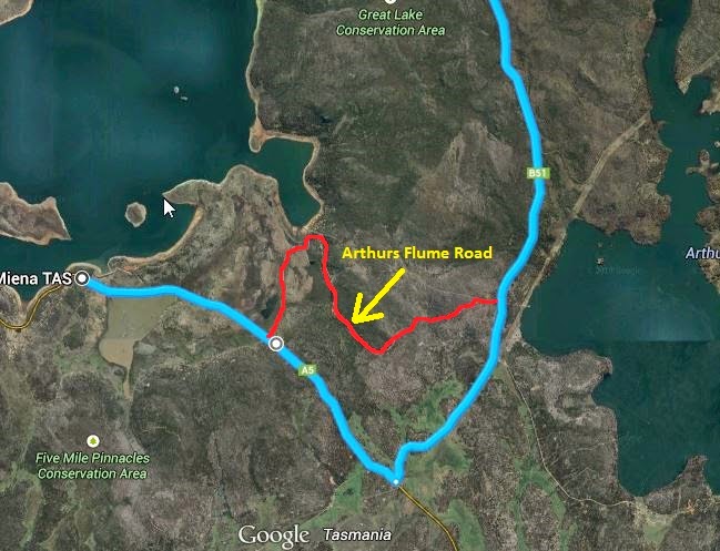
Once again we leave Cheryl and Barry and head down Poatina Road until we turn right and under the boom gate, (there is a second book in here to sign out) then up the hill on Arthurs Flume Road which once at the top of the hill follows the water channel. This road goes to Todd's Corner Road and you can turn right to go to the pump house a few hundred meter down the road or left and back onto Poatina Road. From the Poatina intersection it is only 8km to Miena and about 10km to the Great Lake Hotel where we were staying. Overall 60km ridden and 1600 meters of climbing, 990 meters of it in one hit, still a good day the walking/carrying gave my legs a break (different muscles) and the road ride was fast and furious.
 
The part of the trail my GPS missed. Down Poatina road and onto Arthurs Flume Road

Poatina Road


The channel from Arthurs Lake to Great Lake

Following the channel

Great Lake

Our destination for the day


Sunday, 30 November 2014

Day 1 Devonport to Sheffield

    Nice easy day to start off with a very civilised start time for a Sunday of 1:00pm from the Spirit of Tasmania car park.


    After getting acquainted and loaded up we headed on out of East Devonport through the suburb of Ambleside and along the aptly named River Road along side the Mersey River to the town of Latrobe. We rode up the main street and turned right down Hamilton street which eventually becomes Shale Road.
  The Tasmanian Trail then heads left up the unsealed Old Deloraine Road which has a boom gate across it a few km in. From there we travelled through Forestry plantations until the trail cuts across the middle of a paddock diagonally from corner to corner. On a bike it would be easier to keep following the trail and lift the bikes over two gates instead of riding across a rough paddock full of cow pats and have to lift the bikes over two fences anyway but I can see this would be the better way with horses and a key to the gates. 


    After returning to sealed road we make our way down to Mersey Lea via Native Plains Road then crossed the bridge over the Mersey, our first crossing and most likely the driest. From there we hit the gravel road again until reaching Railton. A short stop for a bite to eat before joining the start of the old railway line track. This part of the trail is the most pleasant as the Tasmanian Trail follows the old railway line from Railton to Sheffield at very rideable gradient.


 Dale had a not so pleasant encounter with an electric fence at this gate.
 

Mount Roland in the background.
 
The old rail trail finishes just at the town of Sheffield and a short ride up the main street brought us to our first days destination. A bit of time to unpack and a post ride rundown before heading up to the pub for a great meal and a few cold drinks.
 

    Tomorrow we have a nice 70 odd km ride with a crossing of the Mersey River to wet our feet before reaching Liffey.